
Surroundings of the apartments
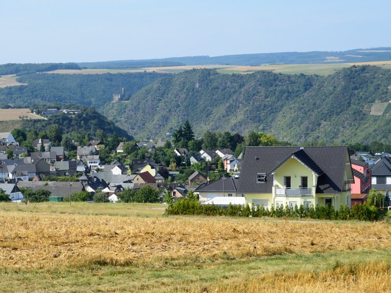
The holiday apartments (Yellowstone, oTTo, and RausZeit) are all located in Biebernheim, a picturesque district of Sankt Goar situated above the impressive Rheinfels Castle. This idyllic Rhine Heights village perches directly on the steep slope of the Rhine Valley on the left bank and treats you to breathtaking panoramic views of the Rhine Valley, the opposite Loreley Rock, or the Taunus region from various viewpoints.
Thanks to their central location in the heart of the UNESCO World Heritage Site „Upper Middle Rhine Valley,“ our holiday apartments not only offer proximity to the region’s numerous attractions but also provide a peaceful, nocturnal tranquility away from any sources of noise such as train traffic, road noise, or ship sounds. This makes our location the ideal choice for relaxation seekers who appreciate the perfect blend of proximity to attractions and quiet nights.
Shopping

You have the option of shopping at a local bakery on site.
For groceries and everyday items, we recommend the town center of St. Goar or the nearby village of Oberwesel (approx. 8 km away).
On the move on foot

Within a few minutes‘ walk, you can not only reach the various viewpoints and Rheinfels Castle, but also the train station and the boat landing stage. This means that planned activities can also be carried out without a car.
Distances
to train station: approx. 1 km
to KD ship’s pier: approx. 1.2 km
to Loreley-Rock: approx. 7 km
to Bacharach: approx. 15 km
to Rüdesheim: approx. 30 km
to Boppard: approx. 16 km
to Koblenz: approx. 35 km
Traveling as a group?

The three vacation apartments are located in close proximity to each other, making it possible to book them as a group of up to 14 people, subject to availability.
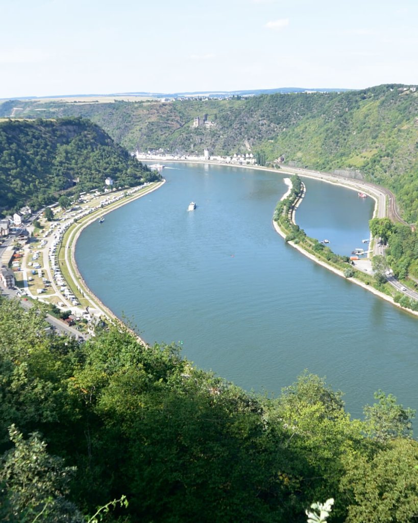
The Upper Middle Rhine Valley
Like something out of a fairy tale, the landscape of the Upper Middle Rhine Valley unfolds, where the majestic Rhine finds its way from Rüdesheim to Koblenz. In June 2002, the „Upper Middle Rhine Valley“ was honored as the first German cultural landscape to be included in the UNESCO World Heritage List.
This extraordinary environment is characterized by the Rhine itself, its narrow strips of shoreline, and the steep slopes, some of which are covered with vineyards. Here, numerous castles, palaces, monasteries, and churches can be found, which, in conjunction with the myths, legends, and artistic masterpieces of literature, music, and visual arts from the 19th century, contributed to the recognition of the 60-kilometer-long Rhine Valley between Bingen/Rüdesheim and Koblenz as a World Heritage Site.
As it flows northward, the Rhine passes through a fairy-tale backdrop of castles and fortresses, winding through narrow valleys and running along steep rock formations. On the western bank rises the Hunsrück, while on the opposite side stretches the Taunus.
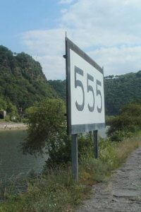
Rheinkilometer 555
The Rhine kilometers are a measurement method that indicates the distance in kilometers from Constance on Lake Constance to the mouth of the Rhine in Rotterdam. These kilometers are counted downstream along the Rhine. To enhance visibility for river navigation, large boards with numbers are placed along the Rhine, displaying the kilometers since the beginning of the Rhine in Constance. These kilometer markers refer to the midpoint of the river and serve as reference points, allowing river navigators to precisely determine their location on the Rhine. The kilometer count starts at 0 kilometers in Constance on Lake Constance and enables the navigation of larger vessels on the Rhine. The Rhine kilometers end at 1036.20 kilometers on the North Sea coast near Hoek van Holland (Rotterdam). For example, Rhine kilometer 167 in Basel indicates that a distance of 167 kilometers has been covered since Constance, while Rhine kilometer 499 in Mainz signifies that 499 kilometers have already been passed since Constance. At Rhine kilometer 555, you’ll find the legendary Loreley Rock…
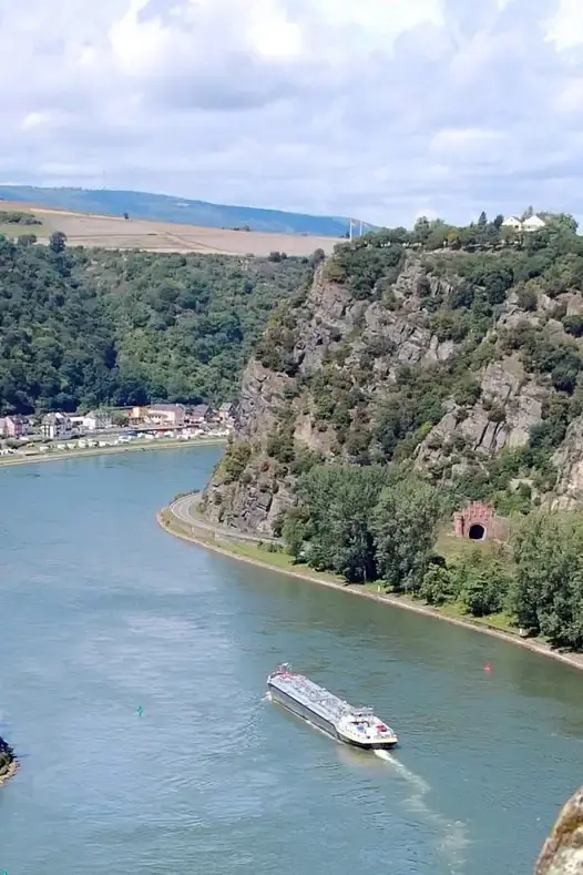
The Loreley
The legendary Loreley Rock rises on the right bank of the Rhine near Sankt Goarshausen. Over the generations, Loreley was both revered and feared by sailors. Until a few years ago, it was considered one of the most dangerous spots for Rhine navigation due to the protruding rock masses from the water, which regularly caused spectacular accidents. However, these rock masses have since been blasted.
The myth of Loreley inspired poets such as Heinrich Heine and Clemens Brentano to write ballads and songs. According to the legend, a beautiful mermaid on the river’s shore lured sailors with her voice, causing them not to notice the strong current and leading them to crash against the rock.
Today, the picturesque Loreley is more of a popular tourist destination than a mystical place of misfortune. From the 125-meter-high rock, you can enjoy an unparalleled view of the meanders of the Rhine and Sankt Goarshausen with Burg Katz. The open-air stage, located a few hundred meters away and built in 1932, serves as a popular backdrop for rock and pop concerts, especially during the summer.